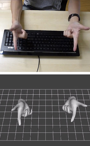
Finger mouse: 3Gear uses depth-sensing cameras to track finger movements.
3Gear Systems
Tuesday, October 16. 2012Google must change privacy policy demand EU watchdogsVia Slash Gear -----
European data protection regulators have demanded Google change its privacy policy, though the French-led team did not conclude that the search giant’s actions amounted to something illegal. The investigation, by the Commission Nationale de l’Informatique (CNIL), argued that Google’s decision to condense the privacy policies of over sixty products into a single agreement – and at the same time increase the amount of inter-service data sharing – could leave users unclear as to how different types of information (as varied as search terms, credit card details, or phone numbers) could be used by the company.
“The Privacy Policy makes no difference in terms of processing between the innocuous content of search query and the credit card number or the telephone communications of the user” the CNIL points out, “all these data can be used equally for all the purposes in the Policy.” That some web users merely interact passively with Google products, such as adverts, also comes in for heightened attention, with those users getting no explanation at all as to how their actions might be tracked or stored.
In a letter to Google [pdf link] – signed by the CNIL and other authorities from across Europe – the concerns are laid out in full, together with some suggestions as to how they can be addressed. For instance, the search company could “develop interactive presentations that allow users to navigate easily through the content of the policies” and “provide additional and precise information about data that have a significant impact on users (location, credit card data, unique device identifiers, telephony, biometrics).” Ironically, one of Google’s arguments for initially changing its policy system was that a single, harmonized agreement would be easier for users to read through and understand. It also insisted that the data-sharing aspects were little changed from before. “The CNIL, all the authorities among the Working Party and data protection authorities from other regions of the world expect Google to take effective and public measures to comply quickly and commit itself to the implementation of these recommendations” the commission concluded. Google has a 3-4 month period to enact the changes requested, or it could face the threat of sanctions. “We have received the report and are reviewing it now” Peter Fleischer, Google’s global privacy counsel, told TechCrunch. “Our new privacy policy demonstrates our long-standing commitment to protecting our users’ information and creating great products. We are confident that our privacy notices respect European law.”
Tuesday, October 09. 2012Meet the Nimble-Fingered Interface of the Future-----
Finger mouse: 3Gear uses depth-sensing cameras to track finger movements.
Microsoft's Kinect, a 3-D camera and software for gaming, has made a big impact since its launch in 2010. Eight million devices were sold in the product's first two months on the market as people clamored to play video games with their entire bodies in lieu of handheld controllers. But while Kinect is great for full-body gaming, it isn't useful as an interface for personal computing, in part because its algorithms can't quickly and accurately detect hand and finger movements. Now a San Francisco-based startup called 3Gear has developed a gesture interface that can track fast-moving fingers. Today the company will release an early version of its software to programmers. The setup requires two 3-D cameras positioned above the user to the right and left. The hope is that developers will create useful applications that will expand the reach of 3Gear's hand-tracking algorithms. Eventually, says Robert Wang, who cofounded the company, 3Gear's technology could be used by engineers to craft 3-D objects, by gamers who want precision play, by surgeons who need to manipulate 3-D data during operations, and by anyone who wants a computer to do her bidding with a wave of the finger. One problem with gestural interfaces—as well as touch-screen desktop displays—is that they can be uncomfortable to use. They sometimes lead to an ache dubbed "gorilla arm." As a result, Wang says, 3Gear focused on making its gesture interface practical and comfortable. "If I want to work at my desk and use gestures, I can't do that all day," he says. "It's not precise, and it's not ergonomic." The key, Wang says, is to use two 3-D cameras above the hands. They are currently rigged on a metal frame, but eventually could be clipped onto a monitor. A view from above means that hands can rest on a desk or stay on a keyboard. (While the 3Gear software development kit is free during its public beta, which lasts until November 30, developers must purchase their own hardware, including cameras and frame.) "Other projects have replaced touch screens with sensors that sit on the desk and point up toward the screen, still requiring the user to reach forward, away from the keyboard," says Daniel Wigdor, professor of computer science at the University of Toronto and author of Brave NUI World, a book about touch and gesture interfaces. "This solution tries to address that." 3Gear isn't alone in its desire to tackle the finer points of gesture tracking. Earlier this year, Microsoft released an update that enabled people who develop Kinect for Windows software to track head position, eyebrow location, and the shape of a mouth. Additionally, Israeli startup Omek, Belgian startup SoftKinetic, and a startup from San Francisco called Leap Motion—which claims its small, single-camera system will track movements to a hundredth of a millimeter—are all jockeying for a position in the fledgling gesture-interface market.
Thursday, October 04. 2012How Google Builds Its Maps—and What It Means for the Future of EverythingVia The Atlantic -----
Behind every Google Map, there is a much more complex map that's the key to your queries but hidden from your view. The deep map contains the logic of places: their no-left-turns and freeway on-ramps, speed limits and traffic conditions. This is the data that you're drawing from when you ask Google to navigate you from point A to point B -- and last week, Google showed me the internal map and demonstrated how it was built. It's the first time the company has let anyone watch how the project it calls GT, or "Ground Truth," actually works. Google opened up at a key moment in its evolution. The company began as an online search company that made money almost exclusively from selling ads based on what you were querying for. But then the mobile world exploded. Where you're searching from has become almost as important as what you're searching for. Google responded by creating an operating system, brand, and ecosystem in Android that has become the only significant rival to Apple's iOS. And for good reason. If Google's mission is to organize all the world's information, the most important challenge -- far larger than indexing the web -- is to take the world's physical information and make it accessible and useful. "If you look at the offline world, the real world in which we live, that information is not entirely online," Manik Gupta, the senior product manager for Google Maps, told me. "Increasingly as we go about our lives, we are trying to bridge that gap between what we see in the real world and [the online world], and Maps really plays that part." This is not just a theoretical concern. Mapping systems matter on phones precisely because they are the interface between the offline and online worlds. If you're at all like me, you use mapping more than any other application except for the communications suite (phone, email, social networks, and text messaging). Google is locked in a battle with the world's largest company, Apple, about who will control the future of mobile phones. Whereas Apple's strengths are in product design, supply chain management, and retail marketing, Google's most obvious realm of competitive advantage is in information. Geo data -- and the apps built to use it -- are where Google can win just by being Google. That didn't matter on previous generations of iPhones because they used Google Maps, but now Apple's created its own service. How the two operating systems incorporate geo data and present it to users could become a key battleground in the phone wars. But that would entail actually building a better map. *** The office where Google has been building the best representation of the world is not a remarkable place. It has all the free food, ping pong, and Google Maps-inspired Christoph Niemann cartoons that you'd expect, but it's still a low-slung office building just off the 101 in Mountain View in the burbs. I was slated to meet with Gupta and the engineering ringleader on his team, former NASA engineer Michael Weiss-Malik, who'd spent his 20 percent time working on Google Mars, and Nick Volmar, an "operator" who actually massages map data. "So you want to make a map," Weiss-Malik tells me as we sit down in front of a massive monitor. "There are a couple of steps. You acquire data through partners. You do a bunch of engineering on that data to get it into the right format and conflate it with other sources of data, and then you do a bunch of operations, which is what this tool is about, to hand massage the data. And out the other end pops something that is higher quality than the sum of its parts." This is what they started out with, the TIGER data from the US Census Bureau (though the base layer could and does come from a variety of sources in different countries). 
On first inspection, this data looks great. The roads look like they are all there and you've got the freeways differentiated. This is a good map to the untrained eye. But let's look closer. There are issues where the digital data does not match the physical world. I've circled a few obvious ones below.
And
that's just from comparing the map to the satellite imagery. But there
are also a variety of other tools at Google's disposal. One is bringing
in data from other sources, say the US Geological Survey. But Google's
Ground Truthers can also bring another exclusive asset to bear on the
maps problem: the Street View cars' tracks and imagery. In keeping with
Google's more-data-is-better-data mantra, the maps team, largely driven
by Street View, is publishing more imagery data every two weeks than
Google possessed total in 2006.*
Let's step
back a tiny bit to recall with wonderment the idea that a single company
decided to drive cars with custom cameras over every road they could
access. Google is up to five million miles driven now. Each drive
generates two kinds of really useful data for mapping. One is the actual
tracks the cars have taken; these are proof-positive that certain
routes can be taken. The other are all the photos. And what's
significant about the photographs in Street View is that Google can run
algorithms that extract the traffic signs and can even paste them onto
the deep map within their Atlas tool. So, for a particularly complicated
intersection like this one in downtown San Francisco, that could look
like this:
 Google
Street View wasn't built to create maps like this, but the geo team
quickly realized that computer vision could get them incredible data for
ground truthing their maps. Not to detour too much, but what you see
above is just the beginning of how Google is going to use Street View
imagery. Think of them as the early web crawlers (remember those?) going
out in the world, looking for the words on pages. That's what Street
View is doing. One of its first uses is finding street signs (and
addresses) so that Google's maps can better understand the logic of
human transportation systems. But as computer vision and OCR improve,
any word that is visible from a road will become a part of Google's
index of the physical world.
Later in the day, Google Maps VP Brian McClendon put it like this: "We can actually organize the world's physical written information if we can OCR it and place it," McClendon said. "We use that to create our maps right now by extracting street names and addresses, but there is a lot more there." More like what? "We already have what we call 'view codes' for 6 million businesses and 20 million addresses, where we know exactly what we're looking at," McClendon continued. "We're able to use logo matching and find out where are the Kentucky Fried Chicken signs ... We're able to identify and make a semantic understanding of all the pixels we've acquired. That's fundamental to what we do." For now, though, computer vision transforming Street View images directly into geo-understanding remains in the future. The best way to figure out if you can make a left turn at a particular intersection is still to have a person look at a sign -- whether that's a human driving or a human looking at an image generated by a Street View car. There is an analogy to be made to one of Google's other impressive projects: Google Translate. What looks like machine intelligence is actually only a recombination of human intelligence. Translate relies on massive bodies of text that have been translated into different languages by humans; it then is able to extract words and phrases that match up. The algorithms are not actually that complex, but they work because of the massive amounts of data (i.e. human intelligence) that go into the task on the front end. Google Maps has executed a similar operation. Humans are coding every bit of the logic of the road onto a representation of the world so that computers can simply duplicate (infinitely, instantly) the judgments that a person already made. This reality is incarnated in Nick Volmar, the operator who has been showing off Atlas while Weiss-Malik and Gupta explain it. He probably uses twenty-five keyboard shortcuts switching between types of data on the map and he shows the kind of twitchy speed that I associate with long-time designers working with Adobe products or professional Starcraft players. Volmar has clearly spent thousands of hours working with this data. Weiss-Malik told me that it takes hundreds of operators to map a country. (Rumor has it many of these people work in the Bangalore office, out of which Gupta was promoted.) The sheer amount of human effort that goes into Google's maps is just mind-boggling. Every road that you see slightly askew in the top image has been hand-massaged by a human. The most telling moment for me came when we looked at couple of the several thousand user reports of problems with Google Maps that come in every day. The Geo team tries to address the majority of fixable problems within minutes. One complaint reported that Google did not show a new roundabout that had been built in a rural part of the country. The satellite imagery did not show the change, but a Street View car had recently driven down the street and its tracks showed the new road perfectly. Volmar began to fix the map, quickly drawing the new road and connecting it to the existing infrastructure. In his haste (and perhaps with the added pressure of three people watching his every move), he did not draw a perfect circle of points. Weiss-Malik and I detoured into another conversation for a couple of minutes. By the time I looked back at the screen, Volmar had redrawn the circle with perfect precision and upgraded a few other things while he was at it. The actions were impressively automatic. This is an operation that promotes perfectionism. And that's how you get your maps to look this this:
Some
details are worth pointing out. In the top at the center, trails have
been mapped out and coded as places for walking. All the parking lots
have been mapped out. All the little roads, say, to the left of the
small dirt patch on the right, have also been coded. Several of the
actual buildings have been outlined. Down at the bottom left, a road has
been marked as a no-go. At each and every intersection, there are
arrows that delineate precisely where cars can and cannot turn.
Now
imagine doing this for every tile on Google's map in the United States
and 30 other countries over the last four years. Every roundabout
perfectly circular, every intersection with the correct logic. Every new
development. Every one-way street. This is a task of a nearly
unimaginable scale. This is not something you can put together with a
few dozen smart engineers.
I came away
convinced that the geographic data Google has assembled is not likely to
be matched by any other company. The secret to this success isn't, as
you might expect, Google's facility with data, but rather its
willingness to commit humans to combining and cleaning data about the
physical world. Google's map offerings build in the human intelligence
on the front end, and that's what allows its computers to tell you the
best route from San Francisco to Boston.
*** It's probably better not to think of Google Maps as a thing like a paper map. Geographic information systems represent a jump from paper maps like the abacus to the computer. "I honestly think we're seeing a more profound change, for map-making, than the switch from manuscript to print in the Renaissance," University of London cartographic historian Jerry Brotton told the Sydney Morning Herald. "That was huge. But this is bigger." The maps we used to keep folded in our glove compartments were a collection of lines and shapes that we overlaid with human intelligence. Now, as we've seen, a map is a collection of lines and shapes with Nick Volmar's (and hundreds of others') intelligence encoded within. It's common when we discuss the future of maps to reference the Borgesian dream of a 1:1 map of the entire world. It seems like a ridiculous notion that we would need a complete representation of the world when we already have the world itself. But to take scholar Nathan Jurgenson's conception of augmented reality seriously, we would have to believe that every physical space is, in his words, "interpenetrated" with information. All physical spaces already are also informational spaces. We humans all hold a Borgesian map in our heads of the places we know and we use it to navigate and compute physical space. Google's strategy is to bring all our mental maps together and process them into accessible, useful forms. Their MapMaker product makes that ambition clear. Project managed by Gupta during his time in India, it's the "bottom up" version of Ground Truth. It's a publicly accessible way to edit Google Maps by adding landmarks and data about your piece of the world. It's a way of sucking data out of human brains and onto the Internet. And it's a lot like Google's open competitor, Open Street Map, which has proven that it, too, can harness the crowd's intelligence. As we slip and slide into a world where our augmented reality is increasingly visible to us off and online, Google's geographic data may become its most valuable asset. Not solely because of this data alone, but because location data makes everything else Google does and knows more valuable. Or as my friend and sci-fi novelist Robin Sloan put it to me, "I maintain that this is Google's core asset. In 50 years, Google will be the self-driving car company (powered by this deep map of the world) and, oh, P.S. they still have a search engine somewhere." Of course, they will always need one more piece of geographic information to make all this effort worthwhile: You. Where you are, that is. Your location is the current that makes Google's giant geodata machine run. They've built this whole playground as an elaborate lure for you. As good and smart and useful as it is, good luck resisting taking the bait.* Due to a
transcription error, an earlier version of this story stated that Google
published 20PB of imagery data every two weeks.
Tuesday, October 02. 2012Questions abound as malicious phpMyAdmin backdoor found on SourceForge siteVia ars technica -----
 A screenshot of a system containing a
malicious backdoor that was snuck into the open-source phpMyAdmin
package. Researchers said the file date may be fraudulent. Developers of phpMyAdmin warned users they may be running a malicious version of the open-source software package after discovering backdoor code was snuck into a package being distributed over the widely used SourceForge repository. The backdoor contains code that allows remote attackers to take control of the underlying server running the modified phpMyAdmin, which is a Web-based tool for managing MySQL databases. The PHP script is found in a file named server_sync.php, and it reads PHP code embedded in standard POST Web requests and then executes it. That allows anyone who knows the backdoor is present to execute code of his choice. HD Moore, CSO of Rapid7 and chief architect of the Metasploit exploit package for penetration testers and hackers, told Ars a module has already been added that tests for the vulnerability. The backdoor is concerning because it was distributed on one of the official mirrors for SourceForge, which hosts more than 324,000 open-source projects, serves more than 46 million consumers, and handles more than four million downloads each day. SourceForge officials are still investigating the breach, so crucial questions remain unanswered. It's still unclear, for instance, if the compromised server hosted other maliciously modified software packages, if other official SourceForge mirror sites were also affected, and if the central repository that feeds these mirror sites might also have been attacked. "If that one mirror was compromised, nearly every SourceForge package on that mirror could have been backdoored, too," Moore said. "So you're looking at not just phpMyAdmin, but 12,000 other projects. If that one mirror was compromised and other projects were modified this isn't just 1,000 people. This is up to a couple hundred thousand." An advisory posted Tuesday on phpMyAdmin said: "One of the SourceForge.net mirrors, namely cdnetworks-kr-1, was being used to distribute a modified archive of phpMyAdmin, which includes a backdoor. This backdoor is located in file server_sync.php and allows an attacker to remotely execute PHP code. Another file, js/cross_framing_protection.js, has also been modified." phpMyAdmin officials didn't respond to e-mails seeking to learn how long the backdoored version had been available and how many people have downloaded it. Update: In a blog post, SourceForge officials said they believe only the affected phpMyAdmin-3.5.2.2-all-languages.zip package was the only modified file on the cdnetworks mirror site, but they are continuing to investigate to make sure. Logs indicate that about 400 people downloaded the malicious package. The provider of the Korea-based mirror has confirmed the breach, which is believe to have happened around September 22, and indicated it was limited to that single mirror site. The machine has been taken out of rotation. "Downloaders are at risk only if a corrupt copy of this software was obtained, installed on a server, and serving was enabled," the SourceForge post said. "Examination of web logs and other server data should help confirm whether this backdoor was accessed." It's not the first time a widely used open-source project has been hit by a breach affecting the security of its many downstream users. In June of last year, WordPress required all account holders on WordPress.org to change their passwords following the discovery that hackers contaminated it with malicious software. Three months earlier, maintainers of the PHP programming language spent several days scouring their source code for malicious modifications after discovering the security of one of their servers had been breached. A three-day security breach in 2010 on ProFTP caused users who downloaded the package during that time to be infected with a malicious backdoor. The main source-code repository for the Free Software Foundation was briefly shuttered that same year following the discovery of an attack that compromised some of the website's account passwords and may have allowed unfettered administrative access. And last August, multiple servers used to maintain and distribute the Linux operating system were infected with malware that gained root system access, although maintainers said the repository was unaffected. Monday, October 01. 2012HP launches Open webOS 1.0Via SlashGear -----
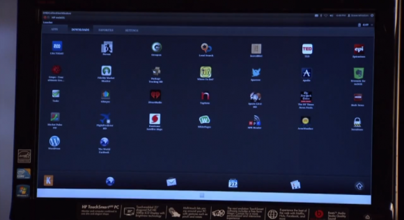
HP‘s TouchPad and Palm devices may be long and gone, but webOS (the mobile OS that these devices ran off of) has been alive and well despite its hardware extinction, mostly thanks to its open-source status. Open webOS, as its now called, went into beta in August, and now a month later, a final stable build is ready for consumption as version 1.0.
The 1.0 release offers some changes that the Open webOS team hopes will offer major new capabilities for developers. The team also mentions that over 75 Open webOS components have been delivered over the past 9 months (totaling over 450,000 lines of code), which means that Open webOS can now be ported to new devices thanks to today’s 1.0 release. In the video below, Open webOS architect Steve Winston demoes the operating system on a HP TouchSmart all-in-one PC. He mentions that it took the team just “a couple of days” to port Open webOS to the PC that he has in front of him. The user interface doesn’t seem to be performing super smoothly, but you can’t really expect more out of a 1.0 release.
Winston says that possible uses for Open webOS include kiosk applications in places like hotels, and since Open webOS is aimed to work on phones, tablets, and PCs, there’s the possibility that Open webOS could become an all-in-one solution for kiosk or customer service platforms for businesses. Obviously, version 1.0 is just the first step, so the Open webOS team is just getting started with this project and they expect to only improve on it and add new features as time goes on. |
QuicksearchPopular Entries
CategoriesShow tagged entriesSyndicate This BlogCalendarBlog Administration |