Tuesday, December 11. 2012
IBM silicon nanophotonics speeds servers with 25Gbps light
Via Slash Gear
-----
IBM has developed a light-based data transfer system delivering more than 25Gbps per channel, opening the door to chip-dense slabs of processing power that could speed up server performance, the internet, and more. The company’s research into silicon integrated nanophotonics addresses concerns that interconnects between increasingly powerful computers, such as mainframe servers, are unable to keep up with the speeds of the computers themselves. Instead of copper or even optical cables, IBM envisages on-chip optical routing, where light blasts data between dense, multi-layer computing hubs.

“This future 3D-integated chip consists of several layers connected with each other with very dense and small pitch interlayer vias. The lower layer is a processor itself with many hundreds of individual cores. Memory layer (or layers) are bonded on top to provide fast access to local caches. On top of the stack is the Photonic layer with many thousands of individual optical devices (modulators, detectors, switches) as well as analogue electrical circuits (amplifiers, drivers, latches, etc.). The key role of a photonic layer is not only to provide point-to-point broad bandwidth optical link between different cores and/or the off-chip traffic, but also to route this traffic with an array of nanophotonic switches. Hence it is named Intra-chip optical network (ICON)” IBM
Optical interconnects are increasingly being used to link different server nodes, but by bringing the individual nodes into a single stack the delays involved in communication could be pared back even further. Off-chip optical communications would also be supported, to link the data-rich hubs together.
Although the photonics system would be considerably faster than existing links – it supports multiplexing, joining multiple 25Gbps+ connections into one cable thanks to light wavelength splitting – IBM says it would also be cheaper thanks to straightforward manufacturing integration:
“By adding a few processing modules into a high-performance 90nm CMOS fabrication line, a variety of silicon nanophotonics components such as wavelength division multiplexers (WDM), modulators, and detectors are integrated side-by-side with a CMOS electrical circuitry. As a result, single-chip optical communications transceivers can be manufactured in a conventional semiconductor foundry, providing significant cost reduction over traditional approaches” IBM
Technologies like the co-developed Thunderbolt from Intel and Apple have promised affordable light-based computing connections, but so far rely on more traditional copper-based links with optical versions further down the line. IBM says its system is “primed for commercial development” though warns it may take a few years before products could actually go on sale.
Friday, November 16. 2012
Misc. Gadgets Voxeljet 3D printer used to produce Skyfall's Aston Martin stunt double
Via engadget
-----

Spoiler alert: a reoccurring cast member bids farewell in the latest James Bond flick. When the production of Skyfall called for the complete decimation of a classic 1960s era Aston Martin DB5, filmmakers opted for something a little more lifelike than computer graphics. The movie studio contracted the services of Augsburg-based 3D printing company Voxeljet to make replicas of the vintage ride. Skipping over the residential-friendly MakerBot Replicator, the company used a beastly industrial VX4000 3D printer to craft three 1:3 scale models of the car with a plot to blow them to smithereens. The 18 piece miniatures were shipped off to Propshop Modelmakers in London to be assembled, painted, chromed and outfitted with fake bullet holes. The final product was used in the film during a high-octane action sequence, which resulted in the meticulously crafted prop receiving a Wile E. Coyote-like sendoff. Now, rest easy knowing that no real Aston Martins were harmed during the making of this film. Head past the break to get a look at a completed model prior to its untimely demise.

Wednesday, October 24. 2012
Molecular 3D bioprinting could mean getting drugs through email
Via dvice
-----

What happens when you combine advances in 3D printing with biosynthesis and molecular construction? Eventually, it might just lead to printers that can manufacture vaccines and other drugs from scratch: email your doc, download some medicine, print it out and you're cured.
This concept (which is surely being worked on as we speak) comes from Craig Venter, whose idea of synthesizing DNA on Mars we posted about last week. You may remember a mention of the possibility of synthesizing Martian DNA back here on Earth, too: Venter says that we can do that simply by having the spacecraft email us genetic information on whatever it finds on Mars, and then recreate it in a lab by mixing together nucleotides in just the right way. This sort of thing has already essentially been done by Ventner, who created the world's first synthetic life form back in 2010.
Vetner's idea is to do away with complex, expensive and centralized vaccine production and instead just develop one single machine that can "print" drugs by carefully combining nucleotides, sugars, amino acids, and whatever else is needed while u wait. Technology like this would mean that vaccines could be produced locally, on demand, simply by emailing the appropriate instructions to your closes drug printer. Pharmacies would no longer consists of shelves upon shelves of different pills, but could instead be kiosks with printers inside them. Ultimately, this could even be something you do at home.
While the benefits to technology like this are obvious, the risks are equally obvious. I mean, you'd basically be introducing the Internet directly into your body. Just ingest that for a second and think about everything that it implies. Viruses. LOLcats. Rule 34. Yeah, you know what, maybe I'll just stick with modern American healthcare and making ritual sacrifices to heathen gods, at least one of which will probably be effective.
Monday, October 15. 2012
Constraints on the Universe as a Numerical Simulation
Thursday, October 04. 2012
How Google Builds Its Maps—and What It Means for the Future of Everything
Via The Atlantic
-----
Behind every Google Map, there is a much more complex map that's the key to your queries but hidden from your view. The deep map contains the logic of places: their no-left-turns and freeway on-ramps, speed limits and traffic conditions. This is the data that you're drawing from when you ask Google to navigate you from point A to point B -- and last week, Google showed me the internal map and demonstrated how it was built. It's the first time the company has let anyone watch how the project it calls GT, or "Ground Truth," actually works.
Google opened up at a key moment in its evolution. The company began as an online search company that made money almost exclusively from selling ads based on what you were querying for. But then the mobile world exploded. Where you're searching from has become almost as important as what you're searching for. Google responded by creating an operating system, brand, and ecosystem in Android that has become the only significant rival to Apple's iOS.
And for good reason. If Google's mission is to organize all the world's information, the most important challenge -- far larger than indexing the web -- is to take the world's physical information and make it accessible and useful.
"If you look at the offline world, the real world in which we live, that information is not entirely online," Manik Gupta, the senior product manager for Google Maps, told me. "Increasingly as we go about our lives, we are trying to bridge that gap between what we see in the real world and [the online world], and Maps really plays that part."
This is not just a theoretical concern. Mapping systems matter on phones precisely because they are the interface between the offline and online worlds. If you're at all like me, you use mapping more than any other application except for the communications suite (phone, email, social networks, and text messaging).
Google is locked in a battle with the world's largest company, Apple, about who will control the future of mobile phones. Whereas Apple's strengths are in product design, supply chain management, and retail marketing, Google's most obvious realm of competitive advantage is in information. Geo data -- and the apps built to use it -- are where Google can win just by being Google. That didn't matter on previous generations of iPhones because they used Google Maps, but now Apple's created its own service. How the two operating systems incorporate geo data and present it to users could become a key battleground in the phone wars.
But that would entail actually building a better map.
***
The office where Google has been building the best representation of the world is not a remarkable place. It has all the free food, ping pong, and Google Maps-inspired Christoph Niemann cartoons that you'd expect, but it's still a low-slung office building just off the 101 in Mountain View in the burbs.
I was slated to meet with Gupta and the engineering ringleader on his team, former NASA engineer Michael Weiss-Malik, who'd spent his 20 percent time working on Google Mars, and Nick Volmar, an "operator" who actually massages map data.
"So you want to make a map," Weiss-Malik tells me as we sit down in front of a massive monitor. "There are a couple of steps. You acquire data through partners. You do a bunch of engineering on that data to get it into the right format and conflate it with other sources of data, and then you do a bunch of operations, which is what this tool is about, to hand massage the data. And out the other end pops something that is higher quality than the sum of its parts."
This is what they started out with, the TIGER data from the US Census Bureau (though the base layer could and does come from a variety of sources in different countries).

On first inspection, this data looks great. The roads look like they are all there and you've got the freeways differentiated. This is a good map to the untrained eye. But let's look closer. There are issues where the digital data does not match the physical world. I've circled a few obvious ones below.


Later in the day, Google Maps VP Brian McClendon put it like this: "We can actually organize the world's physical written information if we can OCR it and place it," McClendon said. "We use that to create our maps right now by extracting street names and addresses, but there is a lot more there."
More like what? "We already have what we call 'view codes' for 6 million businesses and 20 million addresses, where we know exactly what we're looking at," McClendon continued. "We're able to use logo matching and find out where are the Kentucky Fried Chicken signs ... We're able to identify and make a semantic understanding of all the pixels we've acquired. That's fundamental to what we do."
For now, though, computer vision transforming Street View images directly into geo-understanding remains in the future. The best way to figure out if you can make a left turn at a particular intersection is still to have a person look at a sign -- whether that's a human driving or a human looking at an image generated by a Street View car.
There is an analogy to be made to one of Google's other impressive projects: Google Translate. What looks like machine intelligence is actually only a recombination of human intelligence. Translate relies on massive bodies of text that have been translated into different languages by humans; it then is able to extract words and phrases that match up. The algorithms are not actually that complex, but they work because of the massive amounts of data (i.e. human intelligence) that go into the task on the front end.
Google Maps has executed a similar operation. Humans are coding every bit of the logic of the road onto a representation of the world so that computers can simply duplicate (infinitely, instantly) the judgments that a person already made.
This reality is incarnated in Nick Volmar, the operator who has been showing off Atlas while Weiss-Malik and Gupta explain it. He probably uses twenty-five keyboard shortcuts switching between types of data on the map and he shows the kind of twitchy speed that I associate with long-time designers working with Adobe products or professional Starcraft players. Volmar has clearly spent thousands of hours working with this data. Weiss-Malik told me that it takes hundreds of operators to map a country. (Rumor has it many of these people work in the Bangalore office, out of which Gupta was promoted.)
The sheer amount of human effort that goes into Google's maps is just mind-boggling. Every road that you see slightly askew in the top image has been hand-massaged by a human. The most telling moment for me came when we looked at couple of the several thousand user reports of problems with Google Maps that come in every day. The Geo team tries to address the majority of fixable problems within minutes. One complaint reported that Google did not show a new roundabout that had been built in a rural part of the country. The satellite imagery did not show the change, but a Street View car had recently driven down the street and its tracks showed the new road perfectly.
Volmar began to fix the map, quickly drawing the new road and connecting it to the existing infrastructure. In his haste (and perhaps with the added pressure of three people watching his every move), he did not draw a perfect circle of points. Weiss-Malik and I detoured into another conversation for a couple of minutes. By the time I looked back at the screen, Volmar had redrawn the circle with perfect precision and upgraded a few other things while he was at it. The actions were impressively automatic. This is an operation that promotes perfectionism.
And that's how you get your maps to look this this:

***
It's probably better not to think of Google Maps as a thing like a paper map. Geographic information systems represent a jump from paper maps like the abacus to the computer. "I honestly think we're seeing a more profound change, for map-making, than the switch from manuscript to print in the Renaissance," University of London cartographic historian Jerry Brotton told the Sydney Morning Herald. "That was huge. But this is bigger."
The maps we used to keep folded in our glove compartments were a collection of lines and shapes that we overlaid with human intelligence. Now, as we've seen, a map is a collection of lines and shapes with Nick Volmar's (and hundreds of others') intelligence encoded within.
It's common when we discuss the future of maps to reference the Borgesian dream of a 1:1 map of the entire world. It seems like a ridiculous notion that we would need a complete representation of the world when we already have the world itself. But to take scholar Nathan Jurgenson's conception of augmented reality seriously, we would have to believe that every physical space is, in his words, "interpenetrated" with information. All physical spaces already are also informational spaces. We humans all hold a Borgesian map in our heads of the places we know and we use it to navigate and compute physical space. Google's strategy is to bring all our mental maps together and process them into accessible, useful forms.
Their MapMaker product makes that ambition clear. Project managed by Gupta during his time in India, it's the "bottom up" version of Ground Truth. It's a publicly accessible way to edit Google Maps by adding landmarks and data about your piece of the world. It's a way of sucking data out of human brains and onto the Internet. And it's a lot like Google's open competitor, Open Street Map, which has proven that it, too, can harness the crowd's intelligence.
As we slip and slide into a world where our augmented reality is increasingly visible to us off and online, Google's geographic data may become its most valuable asset. Not solely because of this data alone, but because location data makes everything else Google does and knows more valuable.
Or as my friend and sci-fi novelist Robin Sloan put it to me, "I maintain that this is Google's core asset. In 50 years, Google will be the self-driving car company (powered by this deep map of the world) and, oh, P.S. they still have a search engine somewhere."
Of course, they will always need one more piece of geographic information to make all this effort worthwhile: You. Where you are, that is. Your location is the current that makes Google's giant geodata machine run. They've built this whole playground as an elaborate lure for you. As good and smart and useful as it is, good luck resisting taking the bait.Thursday, September 20. 2012
Three-Minute Tech: LTE
Via TechHive
-----
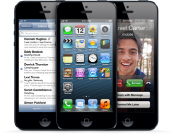
The iPhone 5 is the latest smartphone to hop on-board the LTE (Long Term Evolution) bandwagon, and for good reason: The mobile broadband standard is fast, flexible, and designed for the future. Yet LTE is still a young technology, full of growing pains. Here’s an overview of where it came from, where it is now, and where it might go from here.
The evolution of ‘Long Term Evolution’
LTE is a mobile broadband standard developed by the 3GPP (3rd Generation Partnership Project), a group that has developed all GSM standards since 1999. (Though GSM and CDMA—the network Verizon and Sprint use in the United States—were at one time close competitors, GSM has emerged as the dominant worldwide mobile standard.)
Cell networks began as analog, circuit-switched systems nearly identical in function to the public switched telephone network (PSTN), which placed a finite limit on calls regardless of how many people were speaking on a line at one time.
The second-generation, GPRS, added data (at dial-up modem speed). GPRS led to EDGE, and then 3G, which treated both voice and data as bits passing simultaneously over the same network (allowing you to surf the web and talk on the phone at the same time).
GSM-evolved 3G (which brought faster speeds) started with UMTS, and then accelerated into faster and faster variants of 3G, 3G+, and “4G” networks (HSPA, HSDPA, HSUPA, HSPA+, and DC-HSPA).
Until now, the term “evolution” meant that no new standard broke or failed to work with the older ones. GSM, GPRS, UMTS, and so on all work simultaneously over the same frequency bands: They’re intercompatible, which made it easier for carriers to roll them out without losing customers on older equipment. But these networks were being held back by compatibility.
That’s where LTE comes in. The “long term” part means: “Hey, it’s time to make a big, big change that will break things for the better.”
LTE needs its own space, man
LTE has “evolved” beyond 3G networks by incorporating new radio technology and adopting new spectrum. It allows much higher speeds than GSM-compatible standards through better encoding and wider channels. (It’s more “spectrally efficient,” in the jargon.)
LTE is more flexible than earlier GSM-evolved flavors, too: Where GSM’s 3G variants use 5 megahertz (MHz) channels, LTE can use a channel size from 1.4 MHz to 20 MHz; this lets it work in markets where spectrum is scarce and sliced into tiny pieces, or broadly when there are wide swaths of unused or reassigned frequencies. In short, the wider the channel—everything else being equal—the higher the throughput.
Speeds are also boosted through MIMO (multiple input, multiple output), just as in 802.11n Wi-Fi. Multiple antennas allow two separate benefits: better reception, and multiple data streams on the same spectrum.
LTE complications
Unfortunately, in practice, LTE implementation gets sticky: There are 33 potential bands for LTE, based on a carrier’s local regulatory domain. In contrast, GSM has just 14 bands, and only five of those are widely used. (In broad usage, a band is two sets of paired frequencies, one devoted to upstream traffic and the other committed to downstream. They can be a few MHz apart or hundreds of MHz apart.)
And while LTE allows voice, no standard has yet been agreed upon; different carriers could ultimately choose different approaches, leaving it to handset makers to build multiple methods into a single phone, though they’re trying to avoid that. In the meantime, in the U.S., Verizon and AT&T use the older CDMA and GSM networks for voice calls, and LTE for data.
LTE in the United States
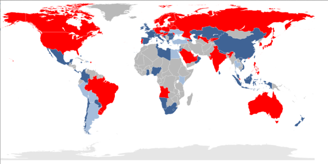
Of the four major U.S. carriers, AT&T, Verizon, and Sprint have LTE networks, with T-Mobile set to start supporting LTE in the next year. But that doesn’t mean they’re set to play nice. We said earlier that current LTE frequencies are divided up into 33 spectrum bands: With the exception of AT&T and T-Mobile, which share frequencies in band 4, each of the major U.S. carriers has its own band. Verizon uses band 13; Sprint has spectrum in band 26; and AT&T holds band 17 in addition to some crossover in band 4.
In addition, smaller U.S. carriers, like C Spire, U.S. Cellular, and Clearwire, all have their own separate piece of the spectrum pie: C Spire and U.S. Cellular use band 12, while Clearwire uses band 41.
As such, for a manufacturer to support LTE networks in the United States alone, it would need to build a receiver that could tune into seven different LTE bands—let alone the various flavors of GSM-evolved or CDMA networks.
With the iPhone, Apple tried to cut through the current Gordian Knot by releasing two separate models, the A1428 and A1429, which cover a limited number of different frequencies depending on where they’re activated. (Apple has kindly released a list of countries that support its three iPhone 5 models.) Other companies have chosen to restrict devices to certain frequencies, or to make numerous models of the same phone.
Banded together
Other solutions are coming. Qualcomm made a regulatory filing in June regarding a seven-band LTE chip, which could be in shipping devices before the end of 2012 and could allow a future iPhone to be activated in different fashions. Within a year or so, we should see most-of-the-world phones, tablets, and other LTE mobile devices that work on the majority of large-scale LTE networks.
That will be just in time for the next big thing: LTE-Advanced, the true fulfillment of what was once called 4G networking, with rates that could hit 1 Gbps in the best possible cases of wide channels and short distances. By then, perhaps the chip, handset, and carrier worlds will have converged to make it all work neatly together.
Wednesday, September 19. 2012
A Genome-Wide Association Study Identifies Five Loci Influencing Facial Morphology in Europeans
Tuesday, September 18. 2012
Stretchable, Tattoo-Like Electronics Are Here to Check Your Health
Via Motherboard
-----

Wearable computing is all the rage this year as Google pulls back the curtain on their Glass technology, but some scientists want to take the idea a stage further. The emerging field of stretchable electronics is taking advantage of new polymers that allow you to not just wear your computer but actually become a part of the circuitry. By embedding the wiring into a stretchable polymer, these cutting edge devices resemble human skin more than they do circuit boards. And with a whole host of possible medical uses, that’s kind of the point.
A Cambridge, Massachusetts startup called MC10 is leading the way in stretchable electronics. So far, their products are fairly simple. There’s a patch that’s meant to be installed right on the skin like a temporary tattoo that can sense whether or not the user is hydrated as well as an inflatable balloon catheter that can measure the electronic signals of the user’s heartbeat to search for irregularities like arrythmias. Later this year, they’re launching a mysterious product with Reebok that’s expected to take advantage of the technology’s ability to detect not only heartbeat but also respiration, body temperature, blood oxygenation and so forth.
The joy of stretchable electronics is that the manufacturing process is not unlike that of regular electronics. Just like with a normal microchip, gold electrodes and wires are deposited on to thin silicone wafers, but they’re also embedded in the stretchable polymer substrate. When everything’s in place, the polymer substrate with embedded circuitry can be peeled off and later installed on a new surface. The components that can be added to stretchable surface include sensors, LEDs, transistors, wireless antennas and solar cells for power.
For now, the technology is still the nascent stages, but scientists have high hopes. In the future, you could wear a temporary tattoo that would monitor your vital signs, or doctors might install stretchable electronics on your organs to keep track of their behavior. Stretchable electronics could also be integrated into clothing or paired with a smartphone. Of course, if all else fails, it’ll probably make for some great children’s toys.
Wednesday, August 29. 2012
Swiss sheep to warn shepherds of wolf attacks by SMS
Via Phys Org
-----

"It's the first time that such a system has been tried outdoors," said biologist Jean-Marc Landry, who took part in testing on a Swiss meadow this week. In the trial, reported by the country's news agency ATS, around 10 sheep were each equipped with a heart monitor before being targeted by a pair of Wolfdogs -- both of which were muzzled. During the experiment, the change in the flock's heartbeat was found to be significant enough to imagine a system whereby the sheep could be fitted with a collar that releases a repellent to drive the wolf away, while also sending an SMS to the shepherd. The device is aimed at owners of small flocks who lack the funds to keep a sheepdog, Landry said, adding that it could also be used in tourist areas where guard dogs are not popular. A prototype collar is expected in the autumn and testing is planned in Switzerland and France in 2013. Other countries including Norway are said to be interested. The issue of wolves is a divisive one in Switzerland where the animals appear to be back after a 100-year absence. On July 27 a wolf killed two sheep in St Gall, the first such attack in the eastern canton. (c) 2012 AFP
Read more at: http://phys.org/news/2012-08-swiss-sheep-shepherds-wolf-sms.html#jCp
Read more at: http://phys.org/news/2012-08-swiss-sheep-shepherds-wolf-sms.html#jCp
Read more at: http://phys.org/news/2012-08-swiss-sheep-shepherds-wolf-sms.html#jCp
Read more at: http://phys.org/news/2012-08-swiss-sheep-shepherds-wolf-sms.html#jCp
Tuesday, August 28. 2012
The Facebook camera that can recognise you every time you walk into a shop
Via Daily Mail
-----
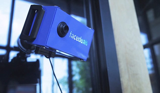
Facedeals - a new camera that can recognise shoppers from their Facebook pictures as they enter a shop, and then offer them discounts
A promotional video created to promote the concept shows drinkers entering a bar, and then being offerend cheap drinks as they are recognised.
'Facebook check-ins are a powerful mechanism for businesses to deliver discounts to loyal customers, yet few businesses—and fewer customers—have realized it,' said Nashville-based advertising agency Redpepper.
They are already trialling the scheme in firms close to their office.
'A search for businesses with active deals in our area turned up a measly six offers.
'The
odds we’ll ever be at one of those six spots are low (a strip club and
photography studio among them), and the incentives for a check-in are
not nearly enticing enough for us to take the time.
'So we set out to evolve the check-in and sweeten the deal, making both irresistible.
'We call it Facedeals.'

The Facedeal camera can identify faces when people walk in by comparing Facebook pictures of people who have signed up to the service
Facebook recently hit the headlines when it bought face.com, an Israeli firm that pioneered the use of face recognition technology online.
The social networking giant uses the software to recognise people in uploaded pictures, allowing it to accurately spot friends.

The software uses a complex algorithm to find the correct person from their Facebook pictures
The Facebook camera requires people to have authorised the Facedeals app through their Facebook account.
This verifies your most recent photo tags and maps the biometric data of your face.
The system then learns what a user looks like as more pictures are approved.
This data is then used to identify you in the real world.
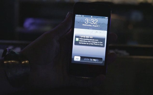
In a demonstration video, the firm behind the camera showed it being used to offer free drinks to customers if they signed up to the system.
Quicksearch
Popular Entries
- The great Ars Android interface shootout (131524)
- Norton cyber crime study offers striking revenue loss statistics (102441)
- MeCam $49 flying camera concept follows you around, streams video to your phone (100539)
- The PC inside your phone: A guide to the system-on-a-chip (58714)
- Norton cyber crime study offers striking revenue loss statistics (58670)
Categories

Show tagged entries
Syndicate This Blog
Calendar
|
|
July '26 | |||||
| Mon | Tue | Wed | Thu | Fri | Sat | Sun |
| 1 | 2 | 3 | 4 | 5 | ||
| 6 | 7 | 8 | 9 | 10 | 11 | 12 |
| 13 | 14 | 15 | 16 | 17 | 18 | 19 |
| 20 | 21 | 22 | 23 | 24 | 25 | 26 |
| 27 | 28 | 29 | 30 | 31 | ||