


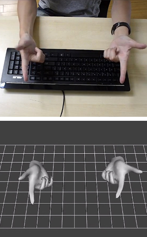
Finger mouse: 3Gear uses depth-sensing cameras to track finger movements.
3Gear Systems
Friday, November 23. 2012Mobile maps showdownVia TechHive -----
Google has enjoyed a considerable head start on the mobile-mapping front, but Apple and Microsoft haven’t been idle. Both companies have licensed data from a number of services to flesh out their competing map offerings in an effort to bolster their respective phone platforms and chip away at Google’s dominance. But there’s more to a map than getting users to and from work: We rely on maps to figure out where we are, to find new places, and to plan trips far beyond our local haunts. Here's a look at which mapping service offers the best features and functionality. A tale of three map appsGoogle Maps 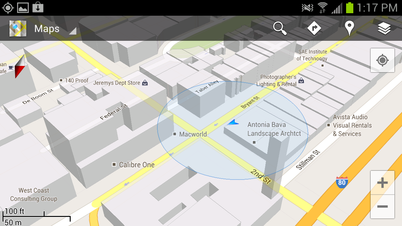 Google Maps’ greatest strength lies in its robust search capabilities: Throughout my testing I found that I could type in a location and (generally) find the business or landmark I was seeking, whereas Apple and Windows Phone often required me to add a city to my search query. Google Maps also offers a killer feature in the form of Street View. If you’ve ever used Google Maps in a browser, you’re likely familiar with the little yellow Pegman avatar that gives you a first-person view of the location you’re searching for. It’s incredibly useful, providing a clear idea of where you’re heading before you ever arrive. The robust direction options are another killer feature. All three mapping services offer directions by car and on foot, but only Google includes public transportation and biking directions. Public transit results can be hit or miss, however—many users have reported that bus schedules and the like don’t necessarily line up with reality, though I’ve had pretty good luck while using the service in San Francisco. Google Maps’ Places functionality serves as a sort of neighborhood-savvy guide: You just tap the pin icon on the map for a list of places nearby, and filtering options let you limit searches to locations that are currently open, fit into a particular price range, or have a minimum review score. Finally, Google Maps displays reviews that its users have posted for most every establishment you could search for, from restaurants to police stations. Apple Maps 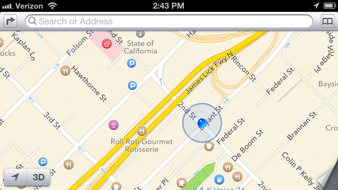 Apple’s flyover view is a novel and admittedly attractive attempt at emulating Google Street View, but ultimately it falls flat. The vector-based maps certainly are eye-catching; but unless you’re actually planning on flying a small plane over your destination, the view won’t offer much in the way of utility. And let’s not forget the often comical rendering issues that are the subject of at least one Tumblr blog, where bridges appear to melt into the landscape and some landmarks disappear entirely. Apple is working on correcting many of these issues, but they do mar Apple Maps’ presentation. Apple has tapped into Yelp’s massive user community to find locations and power its reviews, and that’s a powerful asset in places with an active Yelp community. Unfortunately, Yelp’s business listings are mostly limited to larger cities in the United States, so you’re out of luck if you’re traveling through smaller towns or internationally. Tapping a business name in the Apple Maps app kicks you out of Maps and into the Yelp app—if you don’t have it installed, you’ll be prompted to get it. Swapping between apps can make casual browsing a bit annoying, but Yelp user reviews are decidedly more numerous and robust than Google’s similar offerings. Windows Phone 8 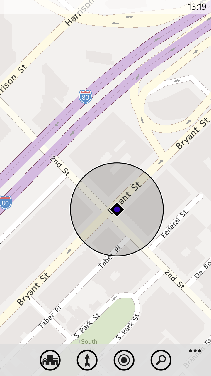 Windows Phone 8 uses Nokia’s mapping engine, but the native Maps application isn’t nearly as robust as the Nokia Drive app currently offered exclusively to Nokia Lumia owners. The Maps app on Windows Phone 8 is ultimately the most limited of the bunch: Although it pulls reviews from sites such as Citysearch and TripAdvisor to fuel its Buzz section, the app lacks photos or any sort of Street View analogue. The Buzz section also has far fewer reviews than Yelp or even Google, which can limit its utility at times. Windows Phone Local Scout is a bit like Google Places, but Microsoft's offering takes top honors. It scans the area around you (or the location you’ve searched for), and lists establishments that are nearby. Results are divided into four categories. 'Eat + Drink' covers bars and restaurants, while the Shop section covers, well, shops. The sections serve up business hours, contact information, and the average ratings assigned by Citysearch and TripAdvisor users. The filtering options are fairly extensive; you can, for example, limit results to restaurants that are open and serving a particular cuisine, or hardware stores that are currently offering deals. The 'See + Do' section lists nearby upcoming events and places of interest—though the unfiltered list is a bit impractical if you’re exploring casually, with museums and art galleries listed alongside New Year’s Eve parties and high school reunions. Finally, there’s the For You section, which couples data from Bing and Facebook to guess what sorts of venues you might be interested in; my suggestions were largely limited to bars, which makes sense based on my admittedly sparse Facebook check-in history. Offline Maps A final useful feature that all three services provide is offline maps. Apple’s implementation is rudimentary: Once you've visited a location on the map, it and the surrounding areas are cached automatically to your device. You won’t be able to search without Wi-Fi or cellular service, but the streets, businesses, and landmarks are preserved in all their vector-mapped glory. If you’re planning in advance, the latest version of Google Maps will let you make sections of a map available offline. Just tap the menu button, choose make available offline, and select a section of the map you’d like to preserve. Alternatively, you can select My Places from the Maps menu, choose new offline map, and search for a city to download a snapshot. The service will tell you exactly how much space the map will take up (in my tests the San Francisco Bay Area claimed approximately 35MB of storage space), and then it will download the section you’ve selected. Unfortunately, you can't search the map without a data connection. Windows Phone’s brute-force approach is actually my favorite implementation: You can download entire maps from a number of regions around the world. Although they take up considerably more space (California weighs in at just shy of 210MB) and you lose out on most of their satellite imagery, you’ll have full search and navigation functionality—even in areas with a spotty data connection. Search shootoutHow do the three services stack up when it comes to finding places you’d like to visit? I did some testing to find out. My testing method was rather simple: I typed in the name of a business or landmark, and examined the results. I’ll start with businesses in San Francisco, home to TechHive headquarters. House of Shields 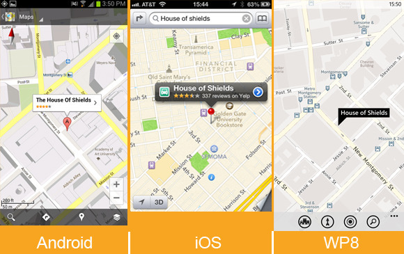 House of Shields is a fairly popular watering hole in the middle of downtown San Francisco, and (as expected) all three phones had no trouble finding it and serving up all of the information I could want. Windows Phone 8’s Buzz section really excelled here, offering a concise breakdown of user reviews. It didn’t have very many reviews, unfortunately. If you’re walking about with friends and trying to get a general idea of a bar’s ambiance, however, the snippets it serves up are arguably more useful than an average user rating from Yelp or Google. Tomales Bay Oyster Company 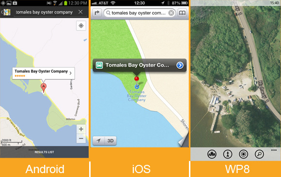 Tomales Bay Oyster Company is a small but lively oyster farm and picnic area located north of San Francisco. It’s a great place to go if you’re craving fresh oysters, looking for a beautiful view, or testing a phone’s mapping app. Google and Apple found the business just fine, pointing their maps to the same isolated turnoff that hosts this delectable little dining spot. Both services offered the restaurant’s phone number, but Google Maps went a bit further, serving up user-submitted photographs of the location, the restaurant’s website and business hours, and reviews from Google Maps users. Windows Phone couldn’t find the business at all, even when I punched in the address and searched for items of interest in the area. I could spot the picnic area by zooming in on the map’s aerial photography, but that kind of information won’t be of much help to most people. State Bird Provisions 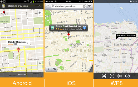 Both iOS and Google Maps found this relatively new restaurant with ease, supplying reviews, contact information, and business hours. On Windows Phone 8 I had to add "San Francisco" to my search before I found the location, and the results included only a phone number and a link to the website. San Francisco’s results are nice, but I also branched farther out in my testing. Totonno’s Pizzeria Napolitano (New York) 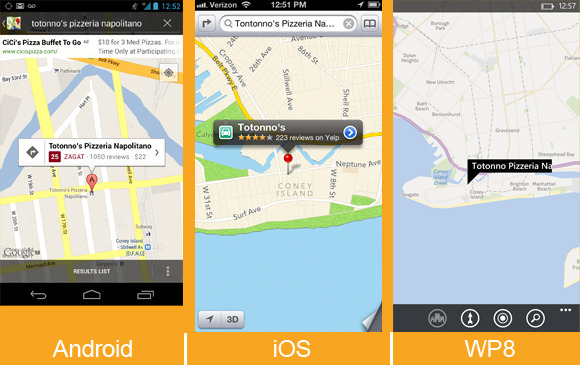 Totonno’s Pizzeria Napolitano is a well-regarded pizza joint in New York, and Google Maps found it effortlessly. Finding the restaurant on iOS required adding "New York" to my search query, but Apple's map turned up all of the necessary information with plenty of photos from Yelp (Google Maps offered only two). Curiously, unless I was looking directly at a map of New York, the Maps app on Windows Phone 8 couldn’t track the restaurant down at all. Once it found the establishment, it gave the necessary contact information and store hours, but served up decidedly fewer user reviews (and no photos). Citizen Coffee (Seattle) 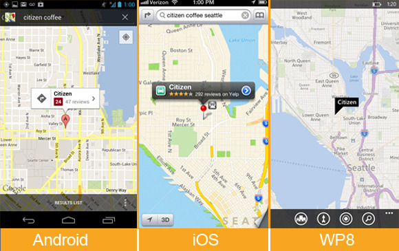 What about a place that's a little less renowned? Citizen Coffee, a cozy coffee shop and eatery in Seattle, is a spot I’ve wandered into a few times while traveling. Google Maps’ search functionality shone on this test, narrowing the location down with ease. On Apple Maps, I needed only to add "Seattle" to my search query to find the place, and the Yelp support produced a lot of photos that gave a nice idea of the variety of food, as well as the ambiance of the establishment. (I still loathe the fact that you need to jump out of the Maps app entirely to check them out, however.) The location was just as easy to find on Windows Phone (once I’d added "Seattle" to my search query), but Windows Phone’s Buzz category once again offered just a few token reviews, and lacked images. Sukiyabashi Jiro (Tokyo) 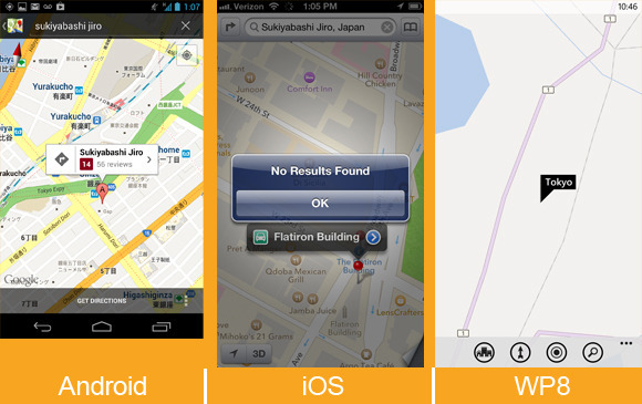 Branching out farther still, I headed to Japan to track down Sukiyabashi Jiro. The restaurant is the subject of the excellent documentary film Jiro Dreams of Sushi, and I assumed that it would be rather easy to track down. Alas, Yelp’s services don’t extend to Japan, so Apple Maps’ offerings for that country are limited to addresses and phone numbers—I couldn’t find Sukiyabashi Jiro at all. Windows Phone 8’s map of Tokyo (and wide swaths of Asia, actually) is barren, lacking even basic information or street names. Unsurprisingly enough, Google Maps delivered in my test, offering the correct address, contact information, and some user reviews. Tracking down business listings in distant cities and foreign countries can prove tricky for iOS and Windows Phone, which rely on licensed services from third parties that don’t have as exhaustive a reach as Google does. I had no such trouble with famous landmarks, though Google Maps’ general location-savvy again made it the most useful of the bunch—most of the time. Taipei 101 (Taipei, Taiwan) 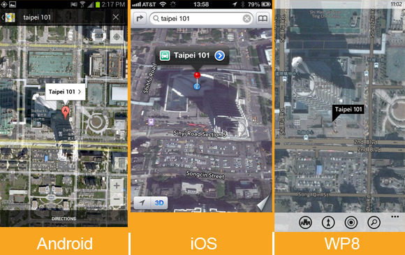 In my quest to find famous landmarks, I started with Taipei 101, the world’s second-largest building. The search took a bit of extra effort on Windows Phone: Oddly, the only query that worked was “Taipei 101, Taipei.” That said, all three services ultimately found the landmark, though only Google Maps provided listings for many of the businesses in the area. Sydney Opera House (Sydney, Australia) 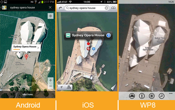 I had better luck tracking down the Sydney Opera House, though Windows Phone 8’s map directed me a few miles southwest of the actual landmark. It’s easy enough to pan over to the site (which is labeled correctly), but Google and Apple Maps both sent me to the right spot on the first try. Flatiron Building (New York) 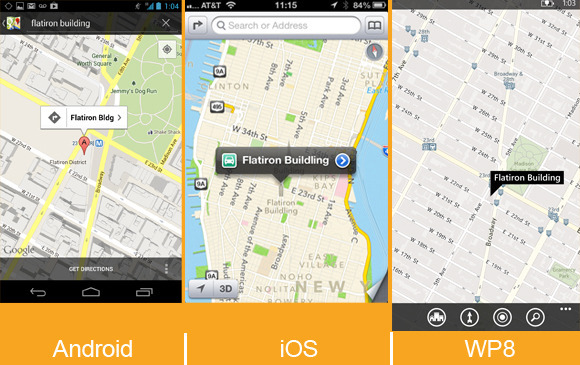 Searching for the iconic Flatiron Building was simple on both Apple Maps and Windows Phone; on iOS’s standard map view, all of New York’s landmarks are helpfully labeled and granted large, distinct icons, which makes casual browsing a breeze. Google initially tried to direct me to The Flatiron Group, a business situated a few blocks south of the landmark, but I was able to locate the building eventually by selecting it from a list of search suggestions. Fenway Park (Boston) 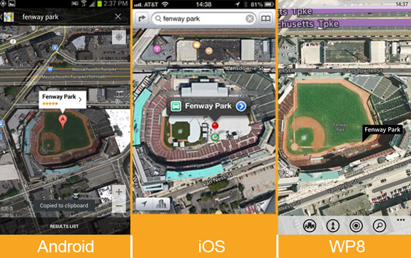 All three mapping services had no trouble finding Fenway Park, home of the Boston Red Sox. Once you arrive at the park (virtually), Windows Phone’s Local Scout offers the easiest way to find nearby establishments; although you can do a generic search on Apple and Google Maps, I appreciated being able to scan a list of interesting locales near the ballpark. Turn-by-turn navigationCompetent turn-by-turn navigation is a must-have feature for anyone who hopes to rely on a phone to get around. Unfortunately, Windows Phone 8’s native Maps app currently lacks support for it. If you own a Nokia Lumia phone, you have access to Nokia’s free Drive app, and the Windows Phone store offers free and paid alternatives for other Windows Phone devices. 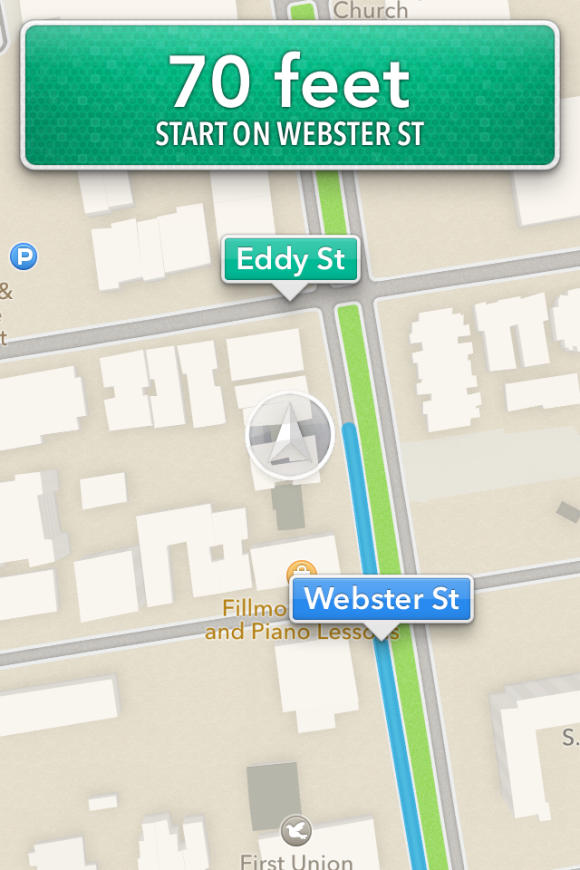 That leaves Apple Maps and Google Maps, two excellent offerings with slightly different implementations. In my tests both services gave accurate directions: The suggestions and even the alternative routes they served up were generally similar (in San Francisco, at least). Miss a turn, and both apps’ robotic narrators will rapidly update their instructions to get you back on the right track. Both will keep you abreast of traffic conditions, and will suggest new routes if the situation looks especially bleak. The Maps app on iOS provides turn-by-turn navigation if you’re running the latest version of iOS and using an iPhone 4S or iPhone 5 (or an iPad 2 or later). The accuracy of the driving directions is on a par with that of Google Maps, but the focus on hands-free simplicity can be a double-edged sword. Setting up a route is easy: Search for a location, select the car icon, and tap the route button, and Siri will begin to relay driving instructions. If you’re focused on getting from point A to point B, this arrangement can be handy; the phone essentially becomes locked to the current step on the list of directions to your destination, ignoring all inputs on the touchscreen unless you leave the app, and even showing directions on the phone’s lock screen. You need to tap the overview button to interact with the map, pausing the route in progress; it’s a small issue, but being able to pan about the map without interrupting directions can be useful if you’d like to gauge traffic congestion in the area or keep an eye out for gas stations and the like on the fly. 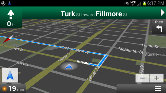 Google Maps shines in navigation. When you’re in navigation mode, the map continues to function normally, so you (or ideally, someone who isn’t driving) can scan for alternative routes or use the layers menu to plot landmarks such as ATMs or gas stations on the map. Google Maps also allows you to create routes that avoid highways and tolls, a simple but useful feature that Apple and Windows Phone would do well to emulate. Truth be told, my only real qualm with Google Maps’ navigation is the awkward overhead angle the app chooses to relay directions. The angle can make it a bit difficult to quickly parse the names of upcoming cross streets and side streets without panning over them on the map, and futzing with your phone isn’t advisable when you’re driving. Which one is the winner?The clear "loser" here is Windows Phone 8, but the maps are largely a victim of the operating system's own infancy. The services can only improve with time, as users add reviews and report errors. The Maps app is constantly evolving, and features such as turn-by-turn navigation are reportedly on the way. I do love Windows Phone’s minimalistic presentation and free map downloads. Local Scout is also arguably the best way to explore a new area, but Microsoft's aerial photography and satellite images are lackluster in comparison with the competition, and the overall feature set is limited. That leaves Google and Apple. iOS’s Maps offering has improved considerably since leaving Google’s mapping data behind, but the reliance on Yelp integration leaves much to be desired for users around the world—to say nothing of the need to switch apps to see most of the information you’re looking for. Apple’s stylish new vector maps are admittedly gorgeous, but offer no real utility; I also found it a bit too easy to slide into the skewed 3D perspective when I was trying to zoom in on a map, which can be a bit disorienting. Unsurprisingly, Google Maps takes the crown. It offers the best search functionality, decidedly better business listings, and robust navigation options. Features such as Street View and Google user reviews allow you to get all of the information you need directly from the app. It isn’t quite as attractive as Apple’s Maps, and Windows Phone’s Local Scout is clearly more useful than Google Places for exploring your surroundings, but Google’s near-decade head start keeps it firmly in the lead.
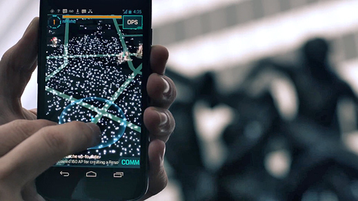
Thursday, November 22. 2012Google Game "Ingress" Could Be Augmented Reality's First Killer App----- Choosing sides: Google’s new augmented-reality game, Ingress, makes users pick a faction—Enlightened or Resistance—and run around town attacking virtual portals in hopes of attaining world domination I’m not usually very political, but I recently joined the Resistance, fighting to protect the world against the encroachment of a strange, newly discovered form of energy. Just this week, in fact, I spent hours protecting Resistance territory and attacking the enemy. Don’t worry, this is just the gloomy sci-fi world depicted in a new smartphone game called Ingress created by Google. Ingress is far from your normal gaming app, though—it takes place, to some degree, in the real world; aspects of the game are revealed only as you reach different real-world locations. Ingress’s world is one in which the discovery of so-called “exotic matter” has split the population into two groups: the Enlightened, who want to learn how to harness the power of this energy, and the Resistance, who, well, resist this change. Players pick a side, and then walk around their city, collecting exotic matter to keep scanners charged and taking control of exotic-matter-exuding portals in order to capture more land for their team. I found the game, which is currently available only to Android smartphone users who have received an invitation to play, surprisingly addictive—especially considering my usual apathy for gaming. What’s most interesting about Ingress, though, is what it suggests about Google’s future plans, which seem to revolve around finding new ways to extend its reach from the browser on your laptop to the devices you carry with you at all times. The goal makes plenty of sense when you consider that traditional online advertising—Google’s bread and butter—could eventually be eclipsed by mobile, location-based advertising. Ingress was created by a group within Google called Niantic Labs—the same team behind another location-based app released recently (see “Should You Go on Google’s Field Trip?”). Google is surely gathering a treasure trove of information about where we’re going and what we’re doing while we play Ingress. It must also see the game as a way to explore possible applications for Project Glass, the augmented-reality glasses-based computer that the company will start sending out to developers next year. Ingress doesn’t require a head-mounted display; it uses your smartphone’s display to show a map view rather than a realistic view of your surroundings. Still, it is addictive, and is likely to get many more folks interested in location-based augmented reality, or at least in augmented-reality games. Despite its futuristic focus, Ingress sports a sort of pseudo-retro look, with a darkly hued map that dominates the screen and a simple pulsing blue triangle that indicates your position. I could only see several blocks in any direction, which meant I had to walk around and explore in order to advance in the game. For a while, I didn’t know what I was doing, and it didn’t help that Ingress doesn’t include any street names. New users complete a series of training exercises, learning the basics of the game, which include capturing a portal, hacking a portal to snag items like resonators (which control said portals), creating links of exotic matter between portals to build a triangular control field that enhances the safety of team members in the area, and firing an XMP (a “non-polarized energy field weapon,” according to the glossary) at an enemy-controlled portal. Confused much? I sure was. But I forged ahead, though, hoping that if I kept playing it would make more sense. I started wandering around looking for portals. Portals are found in public places—in San Francisco, where I was playing, this includes city landmarks such as museums, statues, and murals. Resistance portals are blue, Enlightened ones are green, and there are also some gray ones out there that remain unclaimed. I found a link to a larger map of the Ingress world that I could access through my smartphone browser and made a list of the best-looking nearby targets. Perhaps this much planning goes against the exploratory spirit of the game, but it made Ingress a lot less confusing for me (there’s also a website that doles out clues about the game and its mythology). Once I had a plan, I set out toward the portals on my list, all of which were in the Soma and Downtown neighborhoods of San Francisco. I managed to capture two new portals at Yerba Buena Gardens—one at a statue of Martin Luther King, Jr. and another at the top of a waterfall—and link them together. Across the street, in front of the Contemporary Jewish Museum, I hacked an Enlightened portal and fired an XMP at it, weakening its resonators. I was then promptly attacked. I fled, figuring I wouldn’t be able to take down the portal by myself. A few hours later, much of my progress was undone by a member of Enlightened (Ingress helpfully sends e-mail notifications about such things). I was surprised by how much this pissed me off—I wanted to get those portals back for the Resistance, but pouring rain and the late hour stopped me. Playing Ingress was a lot more fun than I expected, and from the excited chatter in the game’s built-in chat room, it was clear I wasn’t the only one getting into it. On my way back from a meeting, I couldn’t help but keep an eye out for portals, ducking into an alley to attack one near my office. Later, I found myself poring over the larger map on my office computer, looking at the spread of portals and control fields around the Bay Area. As it turns out, my parents live in an area dominated by the Enlightened. So I guess I’ll be busy attacking enemy portals in my hometown this weekend.
Tuesday, November 20. 2012Headband lets you monitor your brain waves via smartphoneVia DVICE -----
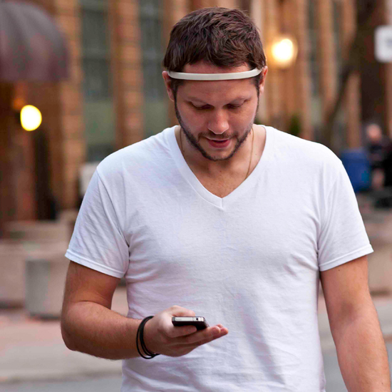
Wearable tech designed to monitor everything from our heart rate to our sleep patterns is becoming increasingly common. However, one group of inventors want to bring that consumer-friendly approach to wearable tech to the arena of brain wave analysis. InteraXon is a Canadian company working on introducing a headband called the Muse, a device that uses a four-sensor EEG (electroencephalography) system to monitor your brain wave patterns. For the initial release, the company is offering a Brain Health system app with the Muse that will allow you to wirelessly monitor your brain wave patterns on your smartphone or tablet device (iOS and Android), as well as on Windows, Mac and Linux desktops. InteraXon is also offering a software development kit for the device to allow other software engineers to build applications that might allow the Muse to be used as a control interface in the future. Currently, the Muse is looking for production financing on Indiegogo, where it has already received a great deal of support.
The device is slated for release in 2013 for $200, but in the meantime,
you can check out a more in-depth explanation of the technology at InteraXon. Thursday, November 08. 2012TouchDevelop Now Available as Web AppVia Technet -----
Monday, November 05. 2012Android 4.2 Announced: Photo Sphere, Gesture Typing, Multi-User, TV Connect, Quick Settings, and Much More!Via xda developpers ----- Retaining the code name from Android 4.1, 4.2 is a revamped version of Jelly Bean. Despite the lack of name change, 4.2 offers various new and exciting features. Join us as we take a closer look at some of the highlights! Photo Sphere and Camera UI Improvements Not too long ago, Google gave us native support for panoramic photos with the launch of ICS. However, in their eyes, a standard panoramic shot doesn’t properly convey the feeling of actually being there. Photo Sphere takes us one step closer.
Once Photo Sphere mode is enabled, the app first guides you as you move your device to capture the entire scene. By using the same technology employed by Google Maps Street View, Photo Sphere then stitches the shots into a 360-degree view that allows you to pan and zoom, as you would in Street View. Those wishing to look at photo spheres from photographers around the would can do so as well. In addition to Photo Sphere, the Camera app’s UI also been updated with gesture controls. Thanks to the gestures, the interface no longer obscures the photo being taken with various controls. Instead, the app now makes full use of the screen real estate so that you can take better photos.
Gesture Typing
Taking a page from Swype’s play book, the new keyboard built into Android 4.2 has slide gesture functionality. The heavily revised keyboard differentiates itself from current versions of Swype, however, by showing predictions in real time, as you slide around your fingers. This isn’t the first time we’ve seen real time gesture recognition—dubstep aside. That said, the interface looks to be better on Google’s latest offering, but the real test will be in actual day to day usage. The dictionaries have also been updated, as has voice recognition.
Multi-User
Remember all the buzz about enabling multi-user support on Android? Apparently, Google does too. We all knew this was coming; it was only a matter of “when.” Well, it’s finally here. Multi-User support has finally made its way to the OS officially. Each user is given his or her own personal space, complete with a customized home screen, background, widgets, apps, and games. While we don’t have access to the source code to verify, this is likely accomplished by sectioning off the /data partition between users. Interestingly, switching between user profiles is done via fast user switching, rather than completely logging in and out. Naturally, this feature is only available / practical on tablets, but you can bet your bacon that this will find its way to phones in the coming months, after 4.2 is released to AOSP.
TV Connect
While we can’t speak in regards to additional functionality for Google’s enigmatic black orb, we can say that this will truly be a useful feature if executed properly. The underlying technology is the new industry standard Miracast, which was created by the Wi-Fi Alliance, and is based on Wi-Fi Direct.
DayDream
A fun, new feature present in 4.2 allows your device to display photo albums, news, and more when your device is docked.
Quick Settings Remember AP’s video showing the “future site of quick settings?” It’s finally here. Google has now added a separate panel to the notification bar that can be accessed by a two-finger swipe from the top of the screen or simple button tap in the upper right corner if the notification tray is extended. Once summoned, it gives you quick access to user accounts, brightness, device settings, WiFi, Airplane Mode, Bluetooth, Battery, and Wireless Display. Lock Screen Widgets Much as we have seen in third party applications, Android now natively supports widgets on the lock screen. In fact, you can now add several pages of widgets to your device’s lock screen, essentially giving you a home screen—before you get to your home screen. Memetastic. Enhanced Google Now Google Now was also updated with more cards. A good example of this is how the software can pick out shipping updates and flight details from your email, and display them in a context-relevant manner. This, however, is not exclusively tied with the updated OS, as those with devices running 4.1 can access the update today.
Friday, November 02. 2012U.S. looks to replace human surveillance with computersVia c|net ----- Security cameras that watch you, and predict what you'll do next, sound like science fiction. But a team from Carnegie Mellon University says their computerized surveillance software will be capable of "eventually predicting" what you're going to do.

Computerized surveillance can predict what people will do next -- it's called "activity forecasting" -- and eventually sound the alarm if the action is not permitted. Click for larger image. (Credit: Carnegie Mellon University)Computer software programmed to detect and report illicit behavior could eventually replace the fallible humans who monitor surveillance cameras. The U.S. government has funded the development of so-called automatic video surveillance technology by a pair of Carnegie Mellon University researchers who disclosed details about their work this week -- including that it has an ultimate goal of predicting what people will do in the future. "The main applications are in video surveillance, both civil and military," Alessandro Oltramari, a postdoctoral researcher at Carnegie Mellon who has a Ph.D. from Italy's University of Trento, told CNET yesterday. Oltramari and fellow researcher Christian Lebiere say automatic video surveillance can monitor camera feeds for suspicious activities like someone at an airport or bus station abandoning a bag for more than a few minutes. "In this specific case, the goal for our system would have been to detect the anomalous behavior," Oltramari says. Think of it as a much, much smarter version of a red light camera: the unblinking eye of computer software that monitors dozens or even thousands of security camera feeds could catch illicit activities that human operators -- who are expensive and can be distracted or sleepy -- would miss. It could also, depending on how it's implemented, raise similar privacy and civil liberty concerns. 
Alessandro Oltramari, left, and Christian Lebiere say their software will "automatize video-surveillance, both in military and civil applications." (Credit: Carnegie Mellon University)A paper (PDF) the researchers presented this week at the Semantic Technology for Intelligence, Defense, and Security conference outside of Washington, D.C. -- today's sessions are reserved only for attendees with top secret clearances -- says their system aims "to approximate human visual intelligence in making effective and consistent detections." Their Army-funded research, Oltramari and Lebiere claim, can go further than merely recognizing whether any illicit activities are currently taking place. It will, they say, be capable of "eventually predicting" what's going to happen next. This approach relies heavily on advances by machine vision researchers, who have made remarkable strides in last few decades in recognizing stationary and moving objects and their properties. It's the same vein of work that led to Google's self-driving cars, face recognition software used on Facebook and Picasa, and consumer electronics like Microsoft's Kinect. When it works well, machine vision can detect objects and people -- call them nouns -- that are on the other side of the camera's lens. But to figure out what these nouns are doing, or are allowed to do, you need the computer science equivalent of verbs. And that's where Oltramari and Lebiere have built on the work of other Carnegie Mellon researchers to create what they call a "cognitive engine" that can understand the rules by which nouns and verbs are allowed to interact. Their cognitive engine incorporates research, called activity forecasting, conducted by a team led by postdoctoral fellow Kris Kitani, which tries to understand what humans will do by calculating which physical trajectories are most likely. They say their software "models the effect of the physical environment on the choice of human actions." Both projects are components of Carnegie Mellon's Mind's Eye architecture, a DARPA-created project that aims to develop smart cameras for machine-based visual intelligence. Predicts Oltramari: "This work should support human operators and automatize video-surveillance, both in military and civil applications." Tuesday, October 16. 2012Google must change privacy policy demand EU watchdogsVia Slash Gear -----
European data protection regulators have demanded Google change its privacy policy, though the French-led team did not conclude that the search giant’s actions amounted to something illegal. The investigation, by the Commission Nationale de l’Informatique (CNIL), argued that Google’s decision to condense the privacy policies of over sixty products into a single agreement – and at the same time increase the amount of inter-service data sharing – could leave users unclear as to how different types of information (as varied as search terms, credit card details, or phone numbers) could be used by the company.
“The Privacy Policy makes no difference in terms of processing between the innocuous content of search query and the credit card number or the telephone communications of the user” the CNIL points out, “all these data can be used equally for all the purposes in the Policy.” That some web users merely interact passively with Google products, such as adverts, also comes in for heightened attention, with those users getting no explanation at all as to how their actions might be tracked or stored.
In a letter to Google [pdf link] – signed by the CNIL and other authorities from across Europe – the concerns are laid out in full, together with some suggestions as to how they can be addressed. For instance, the search company could “develop interactive presentations that allow users to navigate easily through the content of the policies” and “provide additional and precise information about data that have a significant impact on users (location, credit card data, unique device identifiers, telephony, biometrics).” Ironically, one of Google’s arguments for initially changing its policy system was that a single, harmonized agreement would be easier for users to read through and understand. It also insisted that the data-sharing aspects were little changed from before. “The CNIL, all the authorities among the Working Party and data protection authorities from other regions of the world expect Google to take effective and public measures to comply quickly and commit itself to the implementation of these recommendations” the commission concluded. Google has a 3-4 month period to enact the changes requested, or it could face the threat of sanctions. “We have received the report and are reviewing it now” Peter Fleischer, Google’s global privacy counsel, told TechCrunch. “Our new privacy policy demonstrates our long-standing commitment to protecting our users’ information and creating great products. We are confident that our privacy notices respect European law.”
Tuesday, October 09. 2012Meet the Nimble-Fingered Interface of the Future-----
Finger mouse: 3Gear uses depth-sensing cameras to track finger movements.
Microsoft's Kinect, a 3-D camera and software for gaming, has made a big impact since its launch in 2010. Eight million devices were sold in the product's first two months on the market as people clamored to play video games with their entire bodies in lieu of handheld controllers. But while Kinect is great for full-body gaming, it isn't useful as an interface for personal computing, in part because its algorithms can't quickly and accurately detect hand and finger movements. Now a San Francisco-based startup called 3Gear has developed a gesture interface that can track fast-moving fingers. Today the company will release an early version of its software to programmers. The setup requires two 3-D cameras positioned above the user to the right and left. The hope is that developers will create useful applications that will expand the reach of 3Gear's hand-tracking algorithms. Eventually, says Robert Wang, who cofounded the company, 3Gear's technology could be used by engineers to craft 3-D objects, by gamers who want precision play, by surgeons who need to manipulate 3-D data during operations, and by anyone who wants a computer to do her bidding with a wave of the finger. One problem with gestural interfaces—as well as touch-screen desktop displays—is that they can be uncomfortable to use. They sometimes lead to an ache dubbed "gorilla arm." As a result, Wang says, 3Gear focused on making its gesture interface practical and comfortable. "If I want to work at my desk and use gestures, I can't do that all day," he says. "It's not precise, and it's not ergonomic." The key, Wang says, is to use two 3-D cameras above the hands. They are currently rigged on a metal frame, but eventually could be clipped onto a monitor. A view from above means that hands can rest on a desk or stay on a keyboard. (While the 3Gear software development kit is free during its public beta, which lasts until November 30, developers must purchase their own hardware, including cameras and frame.) "Other projects have replaced touch screens with sensors that sit on the desk and point up toward the screen, still requiring the user to reach forward, away from the keyboard," says Daniel Wigdor, professor of computer science at the University of Toronto and author of Brave NUI World, a book about touch and gesture interfaces. "This solution tries to address that." 3Gear isn't alone in its desire to tackle the finer points of gesture tracking. Earlier this year, Microsoft released an update that enabled people who develop Kinect for Windows software to track head position, eyebrow location, and the shape of a mouth. Additionally, Israeli startup Omek, Belgian startup SoftKinetic, and a startup from San Francisco called Leap Motion—which claims its small, single-camera system will track movements to a hundredth of a millimeter—are all jockeying for a position in the fledgling gesture-interface market.
Thursday, October 04. 2012How Google Builds Its Maps—and What It Means for the Future of EverythingVia The Atlantic -----
Behind every Google Map, there is a much more complex map that's the key to your queries but hidden from your view. The deep map contains the logic of places: their no-left-turns and freeway on-ramps, speed limits and traffic conditions. This is the data that you're drawing from when you ask Google to navigate you from point A to point B -- and last week, Google showed me the internal map and demonstrated how it was built. It's the first time the company has let anyone watch how the project it calls GT, or "Ground Truth," actually works. Google opened up at a key moment in its evolution. The company began as an online search company that made money almost exclusively from selling ads based on what you were querying for. But then the mobile world exploded. Where you're searching from has become almost as important as what you're searching for. Google responded by creating an operating system, brand, and ecosystem in Android that has become the only significant rival to Apple's iOS. And for good reason. If Google's mission is to organize all the world's information, the most important challenge -- far larger than indexing the web -- is to take the world's physical information and make it accessible and useful. "If you look at the offline world, the real world in which we live, that information is not entirely online," Manik Gupta, the senior product manager for Google Maps, told me. "Increasingly as we go about our lives, we are trying to bridge that gap between what we see in the real world and [the online world], and Maps really plays that part." This is not just a theoretical concern. Mapping systems matter on phones precisely because they are the interface between the offline and online worlds. If you're at all like me, you use mapping more than any other application except for the communications suite (phone, email, social networks, and text messaging). Google is locked in a battle with the world's largest company, Apple, about who will control the future of mobile phones. Whereas Apple's strengths are in product design, supply chain management, and retail marketing, Google's most obvious realm of competitive advantage is in information. Geo data -- and the apps built to use it -- are where Google can win just by being Google. That didn't matter on previous generations of iPhones because they used Google Maps, but now Apple's created its own service. How the two operating systems incorporate geo data and present it to users could become a key battleground in the phone wars. But that would entail actually building a better map. *** The office where Google has been building the best representation of the world is not a remarkable place. It has all the free food, ping pong, and Google Maps-inspired Christoph Niemann cartoons that you'd expect, but it's still a low-slung office building just off the 101 in Mountain View in the burbs. I was slated to meet with Gupta and the engineering ringleader on his team, former NASA engineer Michael Weiss-Malik, who'd spent his 20 percent time working on Google Mars, and Nick Volmar, an "operator" who actually massages map data. "So you want to make a map," Weiss-Malik tells me as we sit down in front of a massive monitor. "There are a couple of steps. You acquire data through partners. You do a bunch of engineering on that data to get it into the right format and conflate it with other sources of data, and then you do a bunch of operations, which is what this tool is about, to hand massage the data. And out the other end pops something that is higher quality than the sum of its parts." This is what they started out with, the TIGER data from the US Census Bureau (though the base layer could and does come from a variety of sources in different countries). 
On first inspection, this data looks great. The roads look like they are all there and you've got the freeways differentiated. This is a good map to the untrained eye. But let's look closer. There are issues where the digital data does not match the physical world. I've circled a few obvious ones below.
And
that's just from comparing the map to the satellite imagery. But there
are also a variety of other tools at Google's disposal. One is bringing
in data from other sources, say the US Geological Survey. But Google's
Ground Truthers can also bring another exclusive asset to bear on the
maps problem: the Street View cars' tracks and imagery. In keeping with
Google's more-data-is-better-data mantra, the maps team, largely driven
by Street View, is publishing more imagery data every two weeks than
Google possessed total in 2006.*
Let's step
back a tiny bit to recall with wonderment the idea that a single company
decided to drive cars with custom cameras over every road they could
access. Google is up to five million miles driven now. Each drive
generates two kinds of really useful data for mapping. One is the actual
tracks the cars have taken; these are proof-positive that certain
routes can be taken. The other are all the photos. And what's
significant about the photographs in Street View is that Google can run
algorithms that extract the traffic signs and can even paste them onto
the deep map within their Atlas tool. So, for a particularly complicated
intersection like this one in downtown San Francisco, that could look
like this:
 Google
Street View wasn't built to create maps like this, but the geo team
quickly realized that computer vision could get them incredible data for
ground truthing their maps. Not to detour too much, but what you see
above is just the beginning of how Google is going to use Street View
imagery. Think of them as the early web crawlers (remember those?) going
out in the world, looking for the words on pages. That's what Street
View is doing. One of its first uses is finding street signs (and
addresses) so that Google's maps can better understand the logic of
human transportation systems. But as computer vision and OCR improve,
any word that is visible from a road will become a part of Google's
index of the physical world.
Later in the day, Google Maps VP Brian McClendon put it like this: "We can actually organize the world's physical written information if we can OCR it and place it," McClendon said. "We use that to create our maps right now by extracting street names and addresses, but there is a lot more there." More like what? "We already have what we call 'view codes' for 6 million businesses and 20 million addresses, where we know exactly what we're looking at," McClendon continued. "We're able to use logo matching and find out where are the Kentucky Fried Chicken signs ... We're able to identify and make a semantic understanding of all the pixels we've acquired. That's fundamental to what we do." For now, though, computer vision transforming Street View images directly into geo-understanding remains in the future. The best way to figure out if you can make a left turn at a particular intersection is still to have a person look at a sign -- whether that's a human driving or a human looking at an image generated by a Street View car. There is an analogy to be made to one of Google's other impressive projects: Google Translate. What looks like machine intelligence is actually only a recombination of human intelligence. Translate relies on massive bodies of text that have been translated into different languages by humans; it then is able to extract words and phrases that match up. The algorithms are not actually that complex, but they work because of the massive amounts of data (i.e. human intelligence) that go into the task on the front end. Google Maps has executed a similar operation. Humans are coding every bit of the logic of the road onto a representation of the world so that computers can simply duplicate (infinitely, instantly) the judgments that a person already made. This reality is incarnated in Nick Volmar, the operator who has been showing off Atlas while Weiss-Malik and Gupta explain it. He probably uses twenty-five keyboard shortcuts switching between types of data on the map and he shows the kind of twitchy speed that I associate with long-time designers working with Adobe products or professional Starcraft players. Volmar has clearly spent thousands of hours working with this data. Weiss-Malik told me that it takes hundreds of operators to map a country. (Rumor has it many of these people work in the Bangalore office, out of which Gupta was promoted.) The sheer amount of human effort that goes into Google's maps is just mind-boggling. Every road that you see slightly askew in the top image has been hand-massaged by a human. The most telling moment for me came when we looked at couple of the several thousand user reports of problems with Google Maps that come in every day. The Geo team tries to address the majority of fixable problems within minutes. One complaint reported that Google did not show a new roundabout that had been built in a rural part of the country. The satellite imagery did not show the change, but a Street View car had recently driven down the street and its tracks showed the new road perfectly. Volmar began to fix the map, quickly drawing the new road and connecting it to the existing infrastructure. In his haste (and perhaps with the added pressure of three people watching his every move), he did not draw a perfect circle of points. Weiss-Malik and I detoured into another conversation for a couple of minutes. By the time I looked back at the screen, Volmar had redrawn the circle with perfect precision and upgraded a few other things while he was at it. The actions were impressively automatic. This is an operation that promotes perfectionism. And that's how you get your maps to look this this:
Some
details are worth pointing out. In the top at the center, trails have
been mapped out and coded as places for walking. All the parking lots
have been mapped out. All the little roads, say, to the left of the
small dirt patch on the right, have also been coded. Several of the
actual buildings have been outlined. Down at the bottom left, a road has
been marked as a no-go. At each and every intersection, there are
arrows that delineate precisely where cars can and cannot turn.
Now
imagine doing this for every tile on Google's map in the United States
and 30 other countries over the last four years. Every roundabout
perfectly circular, every intersection with the correct logic. Every new
development. Every one-way street. This is a task of a nearly
unimaginable scale. This is not something you can put together with a
few dozen smart engineers.
I came away
convinced that the geographic data Google has assembled is not likely to
be matched by any other company. The secret to this success isn't, as
you might expect, Google's facility with data, but rather its
willingness to commit humans to combining and cleaning data about the
physical world. Google's map offerings build in the human intelligence
on the front end, and that's what allows its computers to tell you the
best route from San Francisco to Boston.
*** It's probably better not to think of Google Maps as a thing like a paper map. Geographic information systems represent a jump from paper maps like the abacus to the computer. "I honestly think we're seeing a more profound change, for map-making, than the switch from manuscript to print in the Renaissance," University of London cartographic historian Jerry Brotton told the Sydney Morning Herald. "That was huge. But this is bigger." The maps we used to keep folded in our glove compartments were a collection of lines and shapes that we overlaid with human intelligence. Now, as we've seen, a map is a collection of lines and shapes with Nick Volmar's (and hundreds of others') intelligence encoded within. It's common when we discuss the future of maps to reference the Borgesian dream of a 1:1 map of the entire world. It seems like a ridiculous notion that we would need a complete representation of the world when we already have the world itself. But to take scholar Nathan Jurgenson's conception of augmented reality seriously, we would have to believe that every physical space is, in his words, "interpenetrated" with information. All physical spaces already are also informational spaces. We humans all hold a Borgesian map in our heads of the places we know and we use it to navigate and compute physical space. Google's strategy is to bring all our mental maps together and process them into accessible, useful forms. Their MapMaker product makes that ambition clear. Project managed by Gupta during his time in India, it's the "bottom up" version of Ground Truth. It's a publicly accessible way to edit Google Maps by adding landmarks and data about your piece of the world. It's a way of sucking data out of human brains and onto the Internet. And it's a lot like Google's open competitor, Open Street Map, which has proven that it, too, can harness the crowd's intelligence. As we slip and slide into a world where our augmented reality is increasingly visible to us off and online, Google's geographic data may become its most valuable asset. Not solely because of this data alone, but because location data makes everything else Google does and knows more valuable. Or as my friend and sci-fi novelist Robin Sloan put it to me, "I maintain that this is Google's core asset. In 50 years, Google will be the self-driving car company (powered by this deep map of the world) and, oh, P.S. they still have a search engine somewhere." Of course, they will always need one more piece of geographic information to make all this effort worthwhile: You. Where you are, that is. Your location is the current that makes Google's giant geodata machine run. They've built this whole playground as an elaborate lure for you. As good and smart and useful as it is, good luck resisting taking the bait.* Due to a
transcription error, an earlier version of this story stated that Google
published 20PB of imagery data every two weeks.
Tuesday, October 02. 2012Questions abound as malicious phpMyAdmin backdoor found on SourceForge siteVia ars technica -----
 A screenshot of a system containing a
malicious backdoor that was snuck into the open-source phpMyAdmin
package. Researchers said the file date may be fraudulent. Developers of phpMyAdmin warned users they may be running a malicious version of the open-source software package after discovering backdoor code was snuck into a package being distributed over the widely used SourceForge repository. The backdoor contains code that allows remote attackers to take control of the underlying server running the modified phpMyAdmin, which is a Web-based tool for managing MySQL databases. The PHP script is found in a file named server_sync.php, and it reads PHP code embedded in standard POST Web requests and then executes it. That allows anyone who knows the backdoor is present to execute code of his choice. HD Moore, CSO of Rapid7 and chief architect of the Metasploit exploit package for penetration testers and hackers, told Ars a module has already been added that tests for the vulnerability. The backdoor is concerning because it was distributed on one of the official mirrors for SourceForge, which hosts more than 324,000 open-source projects, serves more than 46 million consumers, and handles more than four million downloads each day. SourceForge officials are still investigating the breach, so crucial questions remain unanswered. It's still unclear, for instance, if the compromised server hosted other maliciously modified software packages, if other official SourceForge mirror sites were also affected, and if the central repository that feeds these mirror sites might also have been attacked. "If that one mirror was compromised, nearly every SourceForge package on that mirror could have been backdoored, too," Moore said. "So you're looking at not just phpMyAdmin, but 12,000 other projects. If that one mirror was compromised and other projects were modified this isn't just 1,000 people. This is up to a couple hundred thousand." An advisory posted Tuesday on phpMyAdmin said: "One of the SourceForge.net mirrors, namely cdnetworks-kr-1, was being used to distribute a modified archive of phpMyAdmin, which includes a backdoor. This backdoor is located in file server_sync.php and allows an attacker to remotely execute PHP code. Another file, js/cross_framing_protection.js, has also been modified." phpMyAdmin officials didn't respond to e-mails seeking to learn how long the backdoored version had been available and how many people have downloaded it. Update: In a blog post, SourceForge officials said they believe only the affected phpMyAdmin-3.5.2.2-all-languages.zip package was the only modified file on the cdnetworks mirror site, but they are continuing to investigate to make sure. Logs indicate that about 400 people downloaded the malicious package. The provider of the Korea-based mirror has confirmed the breach, which is believe to have happened around September 22, and indicated it was limited to that single mirror site. The machine has been taken out of rotation. "Downloaders are at risk only if a corrupt copy of this software was obtained, installed on a server, and serving was enabled," the SourceForge post said. "Examination of web logs and other server data should help confirm whether this backdoor was accessed." It's not the first time a widely used open-source project has been hit by a breach affecting the security of its many downstream users. In June of last year, WordPress required all account holders on WordPress.org to change their passwords following the discovery that hackers contaminated it with malicious software. Three months earlier, maintainers of the PHP programming language spent several days scouring their source code for malicious modifications after discovering the security of one of their servers had been breached. A three-day security breach in 2010 on ProFTP caused users who downloaded the package during that time to be infected with a malicious backdoor. The main source-code repository for the Free Software Foundation was briefly shuttered that same year following the discovery of an attack that compromised some of the website's account passwords and may have allowed unfettered administrative access. And last August, multiple servers used to maintain and distribute the Linux operating system were infected with malware that gained root system access, although maintainers said the repository was unaffected. |
QuicksearchPopular Entries
CategoriesShow tagged entriesSyndicate This BlogCalendar
Blog Administration |
|||||||||||||||||||||||||||||||||||||||||||||||||


